You have no items in your shopping cart.
C-Map revised MAX Local and 4D Local chart boundaries
C-Map by Jeppesen have broadened their coverage, with more inclusive maps now available for both MAX and 4D local systems.
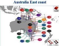
Previously, C-MAP maps were sectioned into cuts providing specific coverage over small sections of the Australian coastline, as shown in the second picture on the right.
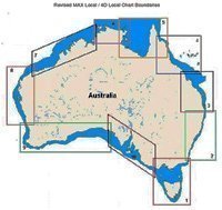
With the newly upgraded system, larger more streamlined cuts are now available in a single map. This splits Australia into ten map sections, which have been adapted to suit both the MAX and 4D Chart systems.
These larger sectioned maps allow for a single purchase, to be used across both systems, covering broader cuts of land. The ten map sections which can be seen in the first picture on the right, Range from; 1) Apollo Bay to Tuross >Head, 2) Turos >Head to Tweed >Head, 3) Tweed >Head to Mackay, 4) Mackay to Princess Charlottee Bay, 5) Princess Charlottee Bay to Cape Grey, 6) Cape Grey to Daly River, 7) Daly River to Onslow, 8) Onslow to Cape Bouvard, 9) Cape Bouvard to Port Eyre and 10) Port Eyre to Apollo Bay.
This updated feature is now available, for more information please contact the staff at CH Smith.
Revised MAX Local and 4D Local Chart Boundaries
Related Products
There are no products matching the selection.


