This product has been discontinued, and replaced with Garmin GPSMAP557 Chartplotter
150mmW x 163mmH x 74mmD Weight: 0.8kg
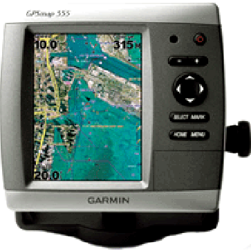
Garmin GPSMAP556 Chart Plotter
SKU: Garmin-GPSMAP556-Chart-Plotter
Brand: Find it In: Marine GPS, Marine Chart Plotters.
Status: Discontinued
Product Description
Details
Garmin GPSMap556 is designed to make life easy with pre-loaded Australian and New Zealand Blue Chart Cartography. Garmin GPSMAP556 is redesigned with new, streamlined user interface for easy selection of modes & features and the GPSMap556 has a single SD memory card slot for optional Blue Chart G2 vision cards.
- BlueChart preloaded with ALL Australia & New Zealand coastal waters.
- High speed processor for ultra fast screen redraw.
- Screen display: 256 colour >VGA LCD 127mm (5") diagonal and 480 x 640 Pixels.
- Track-Up or North-Up Display.
- Trip Computer: Current speed, average speed, resetable maximum speed, trip timer and distance.
- Tracks: Automatic track log; 50 saved tracks (20,000 track points) lets you retrace your path in both directions.
- 3000 Waypoints with name and graphic symbol & proximity support.
- 100 Routes of up to 250 Waypoints plus >MOB.
- NMEA 2000 Interface
- Sun & Moon Rise.
- Alarms: Anchor Drag, arrival, off-course, proximity, clock, Fish, shallow & deep, Battery.
- 12 Channel >WAAS capable GPS Internal Antenna.
- NMEA0183/NMEA2000 compatible.
- Waterproof case to IPX7 standard.
Replacement Parts
Replacement Parts
Options
Options
Specifications
Additional Information
| Replacement Product (SKU) | Garmin-GPSMAP557-Chartplotter |
|---|---|
| Brand | Garmin |
| Country of Manufacture | Unknown |
| Physical Dimensions | 150mmW x 163mmH x 74mmD |
| Screen Size | 5" |
| Display Resolution | 640W x 480V pixel |
| Screen Brightness | Unknown |
| IPX Water Rating | IPX7 |
| Voltage | 12vDC |
| Video Input Ports | None |
| Video Output Ports | None |
| Mounting Options | Bracket Mount |
| Radar Compatible | Yes |
| Waypoints | 3000 |
| Routes | 100 |
| Track Log | 20000 |
| Supports AIS (tracks target ships position) | Yes |
| Tide Tables (from map card option) | Yes |
Reviews


