You have no items in your shopping cart.
What's the difference between Navionics and CMAP MAX N Maps?
If you've been shopping around our site for electronics, you will have come across combos with either CMAP or Navionics XL50 cards. What's the difference, you ask? Read on to find out.
Navionics
Navionics offer three levels of Chart detail known as Silver, Gold and Platinum. Both Gold and Platinum Maps are available in two card sizes, which limit the Chart area. Only Silver and Gold offer All Australia on one card.
Navionics Silver
Navionics Silver is designed to be preloaded in some chartplotters to provide out-of-the-box navigational safety with an enhanced basemap. Silver includes coastlines, drying lines, all Navigation aids, depth information up to 10 meters (30 ft), plus other information as recommended by international standards for safe Navigation with a simplified, uncluttered Chart.
Silver charts do not support Freshest Data and UGC, but any system using Silver can accept Gold or Platinum+ products. There is no upgrade available for Embedded Silver Charts, but Australian Silver charts on Micro SD Cards can be upgraded to Gold.
Navionics Gold (XL50)
Navionics Gold is the 2D flat model and is the most popular Chart with boaters and fishermen all over the world, offering the largest coverage areas along with the absolute best detail.
A Gold Chart can seamlessly cover an entire continent and yet be able to zoom down to a Resolution of 1 meter (3ft), with an abundance of data derived from the best available sources and augmented with Navionics' own surveys and the User Generated Content .
Features include a clear, easy to use, familiar paper-like display of all detail available from the best nautical charts, plus:
• Tides & currents
• Port plans
• User-selectable safety depth contour
• Marine services with phone numbers
• Navigation aids with XPlain
• Marsh areas
Navionics Platinum Plus
Navionics Platinum Plus - what we call the lumps and bumps map!
The multi-dimensional marine charts take the navigational experience to a whole new level with 3D view, integrated Aerial imagery layer, and Port photos. Other coastal photos highlight weed beds. Enjoy perspective well beyond that available from traditional charts, while viewing harbours, marina entrances, and surrounding topography.
Consult geo-referenced Coast Pilot as well as coastal points of interest conveniently while >Underway.
For boaters who don’t venture far beyond their homeport, Platinum+ XL size charts have all the valuable Platinum+ XL3 features, but for a smaller area.
Platinum+ charts are eligible for Freshest Data & User Generated Content . In July 2012 Platinum + Cards included "FishnChips" data so called because it provided additional Bathymetric Depth contours, which are useful in finding and following >Thermoclines or temperature inversions.
CMAP MaxN
C-MAP MaxN charts will appeal to cruising owners, offering unbelievable coverage and detail at a very affordable price. This new mapping system covers large geographical regions, with coastal coverage of Africa, Russia, Asia, Oceania & South Pacific, in Max-level details.
C-MAP MAX-N BDS charts are only available in specific Lowrance, Simrad and B&G bundles, such as the Simrad NSS Sport, Lowrance HDS Gen2, Lowrance Elite-7 HDI and B&G Zeus Touch and are available now! They are not available for separate purchase.
Max-N Wide charts can be purchased on pre-programmed m/SD cards. Existing owners of C-MAP based products can have their cards upgraded to MAX-N Wide format from July 2013.
----------
If you have any further queries, please don't hesitate to contact us at CH Smith Marine in-store, online or by phone (03) 9403 4800.
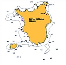

Navionics Silver shows detailed coastline, navaids and depth contours out to 10m

Navionics Gold - shows detailed coastline, navaids and all depth contours as provided on a paper chart
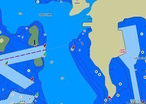
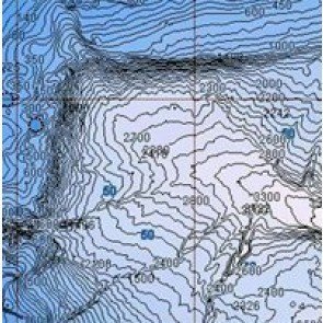
Navionics Platinum Plus - all Gold data and renders depth contours to show peaks and troughs and includes coastal aerial photography and additional bathymetric depth contours