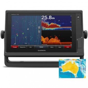
Garmin GPSMAP 952xs Chartplotter Combo
Find it In: Fishing and Marine Electronics, Fish Finder-Plotter Combos.,
Status: Discontinued
Garmin GPSMAP 952xs chartplotter Combo provides an advanced Navigation solution, with a compact 9" high-res intuitive Multi-touch display and full network capabilities including Panoptix all-seeing Sonar.
GPSMAP 952xs combo includes built-in CHIRP Sonar plus CHIRP ClearVu Sonar, with DownVü scanning Sonar. Its internal 10Hz GPS updates your position and heading 10 times per second. GPSMAP 952xs is fully network capable, including wireless connectivity features for Garmin mobile apps, and Garmin Marine Network capabilities for >Radar and Panoptix, including Panoptix FrontVü collision avoidance Sonar.
Plus, there’s NMEA 2000 and NMEA 0183 support for connectivity including autopilots, digital switching, weather, FUSION-Link, VHF, AIS and other sensors.
SailAssist shows your virtual starting Line along with data fields showing laylines, time to burn before the start and a race timer that can be synchronized across all your networked Garmin GPS products. In addition, other supported sailing features include an enhanced wind rose, Heading and course-over-ground lines, set and drift, true and Apparent Wind data and more.
Features:
- Display: 9" multi-touch WVGA display (196mm x 114mm); 1024 x 600 pixels
- IPX7 waterproof protection
- Built-in CHIRP and ClearVü Sonar - compatible with DownVu transducers
- Frequencies: Sonar 50/77/83/200 kHz, CHIRP low, medium, high, ClearVü 260/455/800 kHz
- Usable Depth: 5000 ft at 1kW
- Transmit power: 1 kW traditional, 1 kW CHIRP
- Built-in 10Hz GPS/GLONASS receiver
- Track log: 50,000 points; 50 saved tracks - with 5000 Waypoints and 100 routes
- Garmin Marine Network support for sharing Sonar, including Panoptix™ Sonar, maps, user data, >Radar and IP cameras among multiple units
- SailAssist gives you the competitive edge
- Built-in ANT wireless connectivity directly to Quatix watch, gWind Wireless 2 Transducer, GNX wind marine instrument and wireless remote control
- VIRB action camera integration
- NMEA 2000 and NMEA 0183 support for network connectivity, including autopilots, digital switching, weather, FUSION-Link, VHF, AIS and more
- Video input ports: 1 x BNC
- 2 x MicroSD Data Card slots
- Pre-loaded with Aus & NZ g2 BlueCharts
- Includes GPSMAP 952xs chartplotter, mount kits, cover, power cable, Trim piece snap covers and documentation


