You have no items in your shopping cart.
CMAP Reveal, Navionics Platinum and Navionics+ Maps – what's the difference?
If you've been shopping around our site for electronics, you will have come across combos with either CMAP Reveal, Navionics Platinum or Navionics Plus map cards.
What's the difference, you ask? Read on to find out.
CMAP Reveal
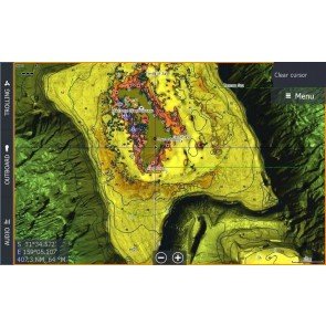
Released this year, C-MAP Reveal sets a new standard in marine fishing charts, providing ultra-high Resolution Bathymetric imagery for Lowrance and Simrad combos.
Up until C-MAP Reveal, we'd relied on Hi Res Bathy data to point to where we want to be. These new charts provide us with so much more navigational information – with 3D view and an integrated Aerial imagery layer.
Reveal highlights key areas within CMAP MAX-N+ regions – showing depth areas, contours, structure and wrecks on the sea floor, tides, currents, marine parks and more in high-res detail.
At present, Reveal is only available in certain defined key areas – but the detail it reveals there is absolutely astounding.
Data provided on Micro SD Card and Full SD Card adapter.
Card exchange required for updates.
For a tutorial on on CMAP Reveal, you can also register for this handy webinar here.
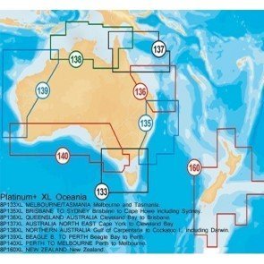
Navionics Platinum
Navionics Platinum Plus - what we call the lumps and bumps map!
Platinum multi-dimensional marine charts provide 3D view, an integrated Aerial imagery layer and Port photos. Other coastal photos highlight weed beds. Enjoy perspective well beyond that available from traditional charts, while viewing harbours, marina entrances, and surrounding topography.
For boaters who don’t venture far beyond their homeport, Platinum+ XL size charts have all the valuable Platinum+ XL3 features, but for a smaller area.
Platinum+ charts are eligible for Freshest Data & User Generated Content. In July 2012 Platinum + Cards included "FishnChips" data so called because it provided additional Bathymetric Depth contours, which are useful in finding and following >Thermoclines or temperature inversions.
Card exchange required for the update.
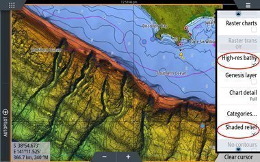
Navionics+
Navionics+ Regions offer smaller, more closely defined areas along the coastline – however without a 3D view or Aerial photgraphic overlay.
These maps are easy to download from wherever you are. You can buy a single card, then download the most up-to-date charts for which ever regions you need – with regular updates through Navionics Community Data (conditions apply).
When downloading the Navionics+ charts, you also have the option for SonarCharts (bathymetric data) to be included as well, which have previously only been available with the Platinum+ charts. This data gives you high definition detail of seabed structure that can help in locating fishing areas.
Updates are free within 12 months of purchase to add/ remove any charts available as many times as you wish – and they're easy to download yourself; no card exchange required. This means you'll always have the most recent maps with the most precise information.
----------
For information on other kinds of maps, check out our article 'What's the difference between Navionics and CMAP MAX-N?'
If you have any further queries, please don't hesitate to contact us at CH Smith Marine in-store, online or by phone (03) 9403 4800.
CMAP Reveal detail of the horseshoe near Port MacDonald
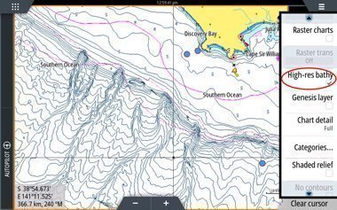
CMAP Reveal - Hi Res Bathymetric Data
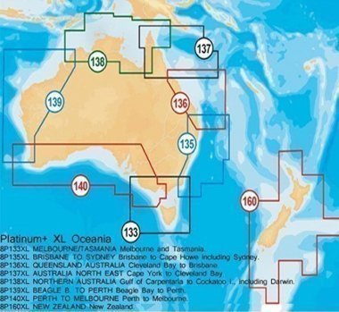
Navionics Platinum XL
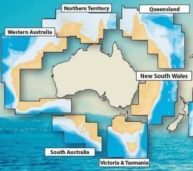
Navionics+ Regions